WR-G420i HRPT/CHRPT Weather Satellite Data Receiver

WR-G420i Weather Satellite Data Receiver

Hardware Features

  120 - 160 MHz input frequency range
  2.5 MHz / 4.5 MHz switchable IF bandwidths
  Coherent BPSK demodulation
  DSP-based split-phase decoding
  DSP-based bit & word synchronization
  Satellite data frame output via PCI bus interface
  Supports NOAA HRPT and FENGYUN CHRPT

The WR-G420i receiver is specially designed for reception and processing of down-converted L-Band weather satellite data signals. It supports HRPT data from the NOAA constellation and CHRPT data from FengYun-1D.

The receiver is powered by an onboard DSP which performs the low-level signal processing functions, assisted by its accompanying Windows application software. The DSP controls functions such as the DPLL, decoding, decoder bit rate selection, bit sync, word sync and the removal of the Manchester encoding from the baseband signal. The decoder bit rate is automatically switched, depending on the received data type (665.4 kbps for HRPT and 1330.8 for CHRPT).

The receiver front end has a PIC-controlled tunable PLL oscillator, which provides tuning steps of 10 kHz. The provision of additional software assistance effectively extends the PLL standard capture range to 400 kHz, which can accommodate large frequency shifts caused by Doppler effects. It also ensures quick and firm locking.

The mixer produces a fixed IF output of 70 MHz, for which the bandwidth is switched between 2.5 MHz for HRPT, and 4.5 MHz for CHRPT.

The second oscillator is coherently locked to the incoming residual carrier frequency, while the second mixer operates as a phase detector to perform BPSK demodulation.

RF signal input into the receiver is via an SMA female connector, which also supplies 12V DC to the downconverter.

The WR-G420i comes in a 2/3 length PCI card form factor with a PCI 2.2 compliant interface. Installation is easy through means of a Windows plug & play Installation Wizard.

See Hardware Specifications for detailed specifications of the WR-G420i receiver.

For our fully-fledged weather satellite system see WSS-420 Weather Satellite System


G420 Software

Software Features

  Automatic dish positioning
  Automated real time polar orbit satellite tracking
  Automated receiver control
  Automated data streaming to disk
  Advanced weather image display and processing
  Data export in NOOA Level 1B / HRPT file format
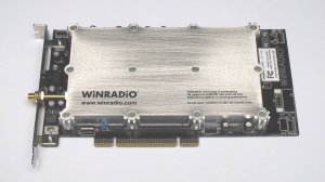
The WR-G420i receiver is shipped with a powerful software application as standard component, included at no extra cost.

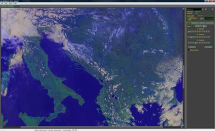
When in Automatic Control mode, the G420i application software provides all the functionality required to automatically track NOOA and FengYun polar orbiting weather satellites in real time, record the data streams transmitted by them, and display a weather image for your location. In Automatic Control mode, all hardware is fully under control of the software. This includes dish positioning, IF bandwidth selection, PLL frequency tuning, AFC and decoder bit rate selection.

The software automatically performs rotator and receiver calibration, if it is required, and allows the user to do so at any other time.

Satellite tracking and data recording is fully automatic and is done by the scheduler, which predicts the position of each satellite, based on TLE data automatically downloaded from the internet on a regular (but configurable) basis. Satellite selection for tracking can be filtered, based on elevation and/or pass duration.

Satellite overlap during tracking is handled on the basis of longest pass duration, but can be manually overridden. Synchronization of the software application clock is configurable and may be taken either from the computer real time clock, or from an NTP server via the internet using the NTP protocol.

Once displayed, advanced image processing can be performed on the weather image, using the sophisticated software tools provided by the application. These include RGB false-colour editing of infrared or non-visible spectral channels, a feature to remove speckle noise, as well as a contrast enhancement function based on histogram equalization. Data can be exported in NOAA Level 1B (HRPT) file format, while images can be saved as BMP, JPG, TIF, GIF and PNG.

When in Manual Control mode, the software provides the user with manual control over dish positioning via rotator azimuth and elevation control, receiver frequency tuning, as well as data recording start and stop.

See Software Specifications for detailed functionality of the WR-G420i application software.


Interested? Please use our Rapid Response Form to register your interest in this product, or to request more information.