WG-8800 VHF/UHF/SHF TDOA Geolocation System

(Preliminary info)

 Proven TDOA (time-difference of arrival) method for accurate position estimation
 Multilateration (hyperbolic) positioning technique
 Wide frequency range of 100 to 8000 MHz
 34 MHz instantaneous bandwidth for capturing signals
 Selectable measurement bandwidths for flexibility
 Scalable architecture supporting 3 or more sensors
 Modulation independent position estimation, suitable for various signal types
 Transportable or stationary deployment options
 Client-server architecture with multi-user networking
 LAN interface for sensor connectivity
 GPS-based timing reference for receiver coherency
 Automatic GPS-based sensor positioning
 Hardware option available for additional antennas
 Mapping feature for visualizing estimated positions
 Built-in self-test functionality for system integrity verification
 Ruggedized and weather-proof construction for reliability
 Rapid and easy system deployment, minimizing setup time and effort

The WiNRADiO WG-8800 VHF/UHF/SHF geolocation system utilizes the proven TDOA method (time-difference of arrival) with statistical signal processing. This integrated hardware/software system accurately estimates the position of transmitters by calculating the signal propagation delay time between multiple sensors. Even when dealing with complex digitally modulated signals, this technique remains highly robust.

The system's design is cost-effective and versatile, making it suitable for a wide range of applications, including government, military, law enforcement, and industrial sectors. Deploying the system is effortless, thanks to its user-friendly setup and robust design. It can be easily used in stationary or transportable deployments, offering exceptional adaptability with minimal constraints.

The system's software-defined radio (SDR) architecture provides unparalleled flexibility, allowing seamless adaptation to various scenarios. Its precision and sensitivity are remarkable, making it not only an excellent position finding system but also a highly capable HF/VHF/UHF COMINT intercept receiver.

WG-8800 VHF/UHF/SHF TDOA Geolocation System


Hardware

The hardware components of the solution are primarily deployed at outdoor sensor sites strategically positioned around the monitored area of interest. A minimum of three sensor sites is required for the system's operation. Each site consists of several key elements, including a multiband omnidirectional high sensitivity antenna, a GPS antenna, a ruggedized waterproof aluminium alloy housing for the sensor receiver and processing systems, and tripods for antenna support.

The system functions seamlessly on the user-provided IP network, which can be either wired or wireless, including cellular connections. The network architecture facilitates efficient communication, with the sensor sites located on one side and the system server and clients on the other side.

In TDOA systems, precise timing is crucial for achieving accurate results. Each sensor site relies on nanosecond-level time precision for optimum performance in position estimation. To achieve this level of precision, our system incorporates a GPS-disciplined OCXO-based time base within the sensor enclosure at each site. This highly accurate time base, combined with the external GPS antenna positioned in close proximity to the main receiving antenna, supplies the essential timing information needed. Additionally, the GPS module allows each sensor to acquire its position, simplifying the installation process and enhancing overall convenience.

An integral component of the system is the receiving antenna, which has been specifically designed to meet its unique requirements. The active discone antenna covers an impressive frequency range, spanning from below 100 MHz up to 8 GHz. Enclosed within a compact and weather-resistant radome, this antenna combines multiple antenna systems. External conical radial elements ensure exceptional reception sensitivity, even at its lowest frequency limit. The antenna's strictly omnidirectional radiation pattern in the horizontal plane provides comprehensive coverage, while integrated band-specific low noise amplifiers further enhance performance.


Software

The software component of the system includes sensor software running within the sensor receiver and processing systems, along with server software and client software typically installed on operator sites. For smaller installations, the server and client software can be conveniently operated on a single workstation, streamlining the setup process.

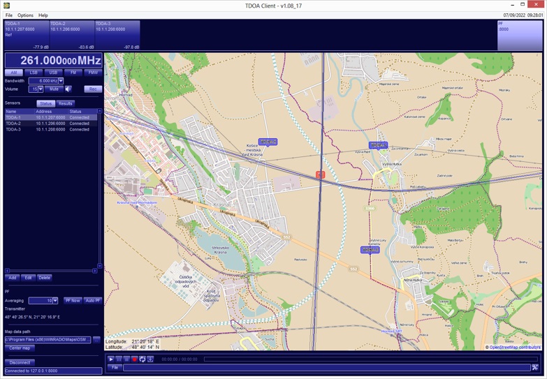
The software offers a wide range of features designed to enhance the user experience. The results of the position estimation process are displayed on an interactive map, providing users with a visual representation of the estimated positions and information about the estimation quality. Additionally, the software enables the display of sensor locations, offering a comprehensive overview of the network. Detailed maps with various levels of zoom and customization options are readily accessible, allowing users to explore specific areas of interest.

To accommodate different operational preferences, the position estimation process can be performed in either manual or automatic mode, providing flexibility and meeting diverse user requirements.

Our software also includes comprehensive network management functionality, empowering users to oversee and manage the entire sensor network. This functionality allows for continuous monitoring of the status and health of individual sensors, ensuring optimal performance and resolution of any potential issues. With our software suite, users benefit from a robust and user-friendly interface that streamlines the operation, monitoring, and management of the sensor network. It provides a powerful toolset for efficient and effective utilization of the system's capabilities.

Technical specifications

Receiver
Frequency range 8 kHz to 8 GHz
Tuning resolution 1 Hz
Image Rejection 60 dB typ.
SFDR 90 dB (Preamp OFF)
85 dB (Preamp ON)
Noise figure 15 dB typ. (Preamp OFF)
6 dB typ. (Preamp ON)
LO Phase noise -106 dBc/Hz @ 10 kHz typ.
Internal spurious below -100 dBm
Processing bandwidth 20 kHz - 32 MHz
Demodulation bandwidth 1 Hz - 320 kHz
Tuning stability 0.001 ppm, GPS disciplined
Antenna inputs 2 x 50 ohm (N connectors)

Frequency and timing reference
Type GNSS disciplined OCXO
Compatible GNSS GPS, GLONASS, GALILEO, BEIDOU
GPS Antenna Active (5V compatible) or Passive

Interfaces
RF inputs 2x N connector, 50 ohm
LAN 10/100/1000 Mbit Ethernet, RJ-45 (female)
DC voltage input 5-pin circular connector (DC IN)
GPS antenna N connector, 50 ohm

General
Power requirements 50 W typical, 90 W peak
Power supply 12 V, 7.5 A
Self-diagnostics BIT (Built-In test), SMA connector
Operating temperature -20 °C to 50 °C (without direct sunlight)
Storage temperature range -20 °C to 70 °C
Dimensions 300 x 220 x 150 mm without pole / wall bracket
Degree of protection IP68
Weight 7.5 kg
Interested? Please use our Rapid Response Form to register your interest in this product, or to request more information.